


BM eu des hauldres 22032023

jeanmarcMasson
User GUIDE
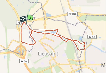

Length
8.8 km

Max alt
92 m

Uphill gradient
51 m
Km-Effort
9.5 km

Min alt
77 m

Downhill gradient
50 m
Boucle
Yes
Creation date :
2023-03-22 12:55:42.0
Updated on :
2023-03-22 15:25:59.731
2h12
Difficulty : Unknown

FREE GPS app for hiking
 SityTrail
IGN / Geographical institutes
SityTrail Plus
The world is yours!
About
Trail Walking of 8.8 km to be discovered at Ile-de-France, Essonne, Tigery. This trail is proposed by jeanmarcMasson.
Positioning
Country:
France
Region :
Ile-de-France
Department/Province :
Essonne
Municipality :
Tigery
Location:
Unknown
Start:(Dec)
Start:(UTM)
466019 ; 5387886 (31U) N.
Comments