


toujours en ba

CDSM 55
User

Length
552 m

Max alt
396 m

Uphill gradient
11 m
Km-Effort
702 m

Min alt
380 m

Downhill gradient
12 m
Boucle
Yes
Creation date :
2023-03-22 14:32:21.443
Updated on :
2023-03-22 16:42:59.463
4m
Difficulty : Easy

FREE GPS app for hiking
 SityTrail
IGN / Geographical institutes
SityTrail Plus
The world is yours!
About
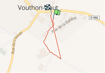
Trail Walking of 552 m to be discovered at Grand Est, Meuse, Vouthon-Haut. This trail is proposed by CDSM 55.
Positioning
Country:
France
Region :
Grand Est
Department/Province :
Meuse
Municipality :
Vouthon-Haut
Location:
Unknown
Start:(Dec)
Start:(UTM)
693506 ; 5372525 (31U) N.
Comments