


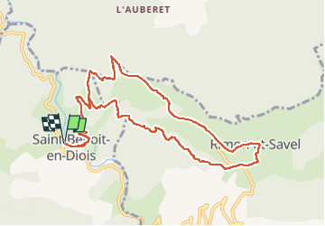
les. balcons de la Roanne depuis St Benoît

alinetpierre
User

Length
12.6 km

Max alt
1000 m

Uphill gradient
722 m
Km-Effort
22 km

Min alt
348 m

Downhill gradient
723 m
Boucle
Yes
Creation date :
2023-03-23 08:25:15.336
Updated on :
2023-03-23 14:36:36.123
3h53
Difficulty : Difficult

FREE GPS app for hiking
 SityTrail
IGN / Geographical institutes
SityTrail Plus
The world is yours!
About
Trail Walking of 12.6 km to be discovered at Auvergne-Rhône-Alpes, Drôme, Saint-Benoit-en-Diois. This trail is proposed by alinetpierre.
Description
passages escarpés
Positioning
Country:
France
Region :
Auvergne-Rhône-Alpes
Department/Province :
Drôme
Municipality :
Saint-Benoit-en-Diois
Location:
Unknown
Start:(Dec)
Start:(UTM)
680119 ; 4948055 (31T) N.
Comments