


Crest-Les roches

ThierryJ01
User
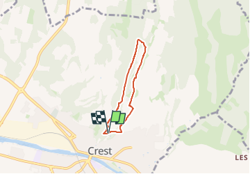

Length
4.5 km

Max alt
412 m

Uphill gradient
183 m
Km-Effort
7 km

Min alt
238 m

Downhill gradient
190 m
Boucle
Yes
Creation date :
2023-03-23 19:52:59.334
Updated on :
2023-03-23 20:13:12.395
1h34
Difficulty : Medium

FREE GPS app for hiking
 SityTrail
IGN / Geographical institutes
SityTrail Plus
The world is yours!
About
Trail Walking of 4.5 km to be discovered at Auvergne-Rhône-Alpes, Drôme, Crest. This trail is proposed by ThierryJ01.
Description
Balade familiale derrière le plus haut donjon de France : vous cheminerez sur des crêtes et profiterez d’un inoubliable panorama sur les montagnes du Vercors, les Trois Becs et le plateau ardéchois.
Positioning
Country:
France
Region :
Auvergne-Rhône-Alpes
Department/Province :
Drôme
Municipality :
Crest
Location:
Unknown
Start:(Dec)
Start:(UTM)
660417 ; 4955105 (31T) N.
Comments