


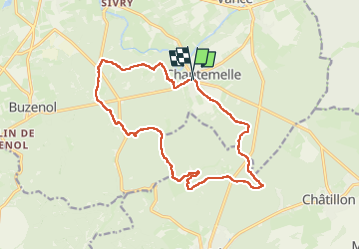
Chanterelle Adeps 2023

fra_depoorter
User

Length
15.6 km

Max alt
365 m

Uphill gradient
198 m
Km-Effort
18.2 km

Min alt
289 m

Downhill gradient
201 m
Boucle
Yes
Creation date :
2023-02-19 07:58:57.806
Updated on :
2023-03-23 21:02:20.176
3h19
Difficulty : Medium

FREE GPS app for hiking
 SityTrail
IGN / Geographical institutes
SityTrail Plus
The world is yours!
About
Trail Walking of 15.6 km to be discovered at Wallonia, Luxembourg, Étalle. This trail is proposed by fra_depoorter.
Positioning
Country:
Belgium
Region :
Wallonia
Department/Province :
Luxembourg
Municipality :
Étalle
Location:
Chantemelle
Start:(Dec)
Start:(UTM)
691347 ; 5503329 (31U) N.
Comments