


2023-03-24_19h04m48_Cirkwi-La_Venise_briarde

jpcccb
User
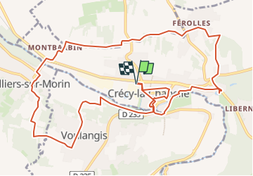

Length
13.6 km

Max alt
135 m

Uphill gradient
213 m
Km-Effort
16.5 km

Min alt
47 m

Downhill gradient
213 m
Boucle
Yes
Creation date :
2023-03-24 18:04:48.118
Updated on :
2024-09-26 11:07:10.393
3h44
Difficulty : Easy

FREE GPS app for hiking
 SityTrail
IGN / Geographical institutes
SityTrail Plus
The world is yours!
About
Trail On foot of 13.6 km to be discovered at Ile-de-France, Seine-et-Marne, Crécy-la-Chapelle. This trail is proposed by jpcccb.
Description
Une randonnée le long des petits canaux ou « brassets » du Grand-Morin. La Chapelle-sur-Crécy mérite un détour pour voir l’un des plus beaux exemples d’églises gothiques en Ile de France.
Positioning
Country:
France
Region :
Ile-de-France
Department/Province :
Seine-et-Marne
Municipality :
Crécy-la-Chapelle
Location:
Unknown
Start:(Dec)
Start:(UTM)
493083 ; 5411820 (31U) N.
Comments