


Berg est

raygautier
User
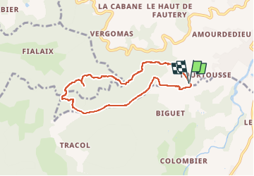

Length
7.3 km

Max alt
412 m

Uphill gradient
382 m
Km-Effort
12.4 km

Min alt
157 m

Downhill gradient
382 m
Boucle
Yes
Creation date :
2023-03-25 10:30:15.0
Updated on :
2023-03-25 16:23:32.939
5h52
Difficulty : Difficult

FREE GPS app for hiking
 SityTrail
IGN / Geographical institutes
SityTrail Plus
The world is yours!
About
Trail Walking of 7.3 km to be discovered at Auvergne-Rhône-Alpes, Ardèche, Saint-Péray. This trail is proposed by raygautier.
Positioning
Country:
France
Region :
Auvergne-Rhône-Alpes
Department/Province :
Ardèche
Municipality :
Saint-Péray
Location:
Unknown
Start:(Dec)
Start:(UTM)
643219 ; 4975990 (31T) N.
Comments