


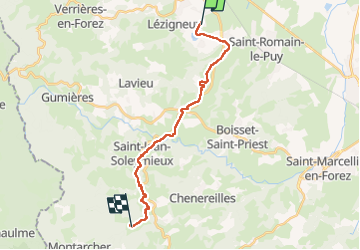
St Thomas la Garde - Chaussy

MAD-CVW
User

Length
18.7 km

Max alt
998 m

Uphill gradient
811 m
Km-Effort
28 km

Min alt
417 m

Downhill gradient
280 m
Boucle
No
Creation date :
2023-03-26 07:28:47.517
Updated on :
2023-03-26 15:44:37.066
4h58
Difficulty : Very difficult

FREE GPS app for hiking
 SityTrail
IGN / Geographical institutes
SityTrail Plus
The world is yours!
About
Trail Walking of 18.7 km to be discovered at Auvergne-Rhône-Alpes, Loire, Saint-Thomas-la-Garde. This trail is proposed by MAD-CVW.
Positioning
Country:
France
Region :
Auvergne-Rhône-Alpes
Department/Province :
Loire
Municipality :
Saint-Thomas-la-Garde
Location:
Unknown
Start:(Dec)
Start:(UTM)
584294 ; 5046531 (31T) N.
Comments