


Rochefort

canal
User
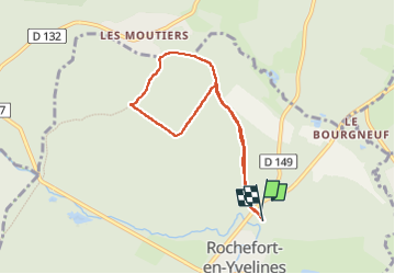

Length
6.5 km

Max alt
149 m

Uphill gradient
85 m
Km-Effort
7.6 km

Min alt
105 m

Downhill gradient
84 m
Boucle
Yes
Creation date :
2023-03-27 07:59:16.502
Updated on :
2023-03-27 09:42:42.26
1h43
Difficulty : Medium

FREE GPS app for hiking
 SityTrail
IGN / Geographical institutes
SityTrail Plus
The world is yours!
About
Trail Walking of 6.5 km to be discovered at Ile-de-France, Yvelines, Rochefort-en-Yvelines. This trail is proposed by canal.
Positioning
Country:
France
Region :
Ile-de-France
Department/Province :
Yvelines
Municipality :
Rochefort-en-Yvelines
Location:
Unknown
Start:(Dec)
Start:(UTM)
425545 ; 5382544 (31U) N.
Comments