


Prades 27/03/23

Linerou
User
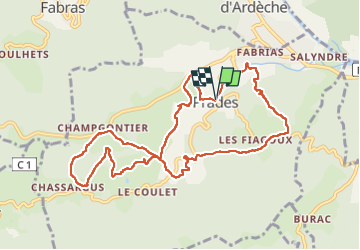

Length
11 km

Max alt
416 m

Uphill gradient
361 m
Km-Effort
15.8 km

Min alt
270 m

Downhill gradient
360 m
Boucle
Yes
Creation date :
2023-03-27 07:21:01.719
Updated on :
2023-03-27 10:42:35.0
3h20
Difficulty : Medium

FREE GPS app for hiking
 SityTrail
IGN / Geographical institutes
SityTrail Plus
The world is yours!
About
Trail Walking of 11 km to be discovered at Auvergne-Rhône-Alpes, Ardèche, Prades. This trail is proposed by Linerou.
Positioning
Country:
France
Region :
Auvergne-Rhône-Alpes
Department/Province :
Ardèche
Municipality :
Prades
Location:
Unknown
Start:(Dec)
Start:(UTM)
604385 ; 4943628 (31T) N.
Comments