


J6

MAD-CVW
User

Length
22 km

Max alt
1173 m

Uphill gradient
439 m
Km-Effort
29 km

Min alt
874 m

Downhill gradient
584 m
Boucle
No
Creation date :
2023-03-27 07:45:30.207
Updated on :
2023-03-27 15:12:16.488
5h13
Difficulty : Very difficult

FREE GPS app for hiking
 SityTrail
IGN / Geographical institutes
SityTrail Plus
The world is yours!
About
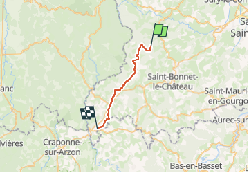
Trail Walking of 22 km to be discovered at Auvergne-Rhône-Alpes, Loire, Marols. This trail is proposed by MAD-CVW.
Description
réalisation
Positioning
Country:
France
Region :
Auvergne-Rhône-Alpes
Department/Province :
Loire
Municipality :
Marols
Location:
Unknown
Start:(Dec)
Start:(UTM)
579832 ; 5035941 (31T) N.
Comments