


Valmeinier-Col des Marches et Lac Bissorte

nicolas54230
User
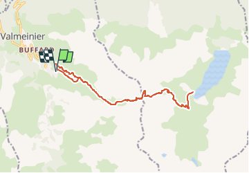

Length
18.1 km

Max alt
2713 m

Uphill gradient
1453 m
Km-Effort
38 km

Min alt
1857 m

Downhill gradient
1453 m
Boucle
Yes
Creation date :
2023-03-27 19:40:41.216
Updated on :
2023-03-27 19:41:56.105
8h31
Difficulty : Difficult

FREE GPS app for hiking
 SityTrail
IGN / Geographical institutes
SityTrail Plus
The world is yours!
About
Trail On foot of 18.1 km to be discovered at Auvergne-Rhône-Alpes, Savoy, Valmeinier. This trail is proposed by nicolas54230.
Positioning
Country:
France
Region :
Auvergne-Rhône-Alpes
Department/Province :
Savoy
Municipality :
Valmeinier
Location:
Unknown
Start:(Dec)
Start:(UTM)
303390 ; 5005207 (32T) N.
Comments