


Valmeinier-Lac Vert et Refuge Terre Rouge

nicolas54230
User
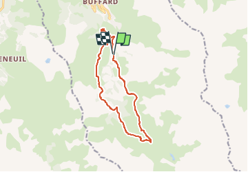

Length
13 km

Max alt
2185 m

Uphill gradient
730 m
Km-Effort
23 km

Min alt
1637 m

Downhill gradient
735 m
Boucle
Yes
Creation date :
2023-03-27 20:04:22.212
Updated on :
2023-03-27 20:05:08.26
5h10
Difficulty : Medium

FREE GPS app for hiking
 SityTrail
IGN / Geographical institutes
SityTrail Plus
The world is yours!
About
Trail On foot of 13 km to be discovered at Auvergne-Rhône-Alpes, Savoy, Valmeinier. This trail is proposed by nicolas54230.
Positioning
Country:
France
Region :
Auvergne-Rhône-Alpes
Department/Province :
Savoy
Municipality :
Valmeinier
Location:
Unknown
Start:(Dec)
Start:(UTM)
303084 ; 5003973 (32T) N.
Comments