


Valmeinier-Le Pré abandonné

nicolas54230
User
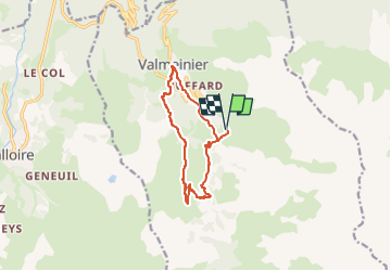

Length
11 km

Max alt
2040 m

Uphill gradient
735 m
Km-Effort
21 km

Min alt
1488 m

Downhill gradient
735 m
Boucle
Yes
Creation date :
2023-03-27 20:11:10.364
Updated on :
2023-03-27 20:11:46.722
4h43
Difficulty : Medium

FREE GPS app for hiking
 SityTrail
IGN / Geographical institutes
SityTrail Plus
The world is yours!
About
Trail On foot of 11 km to be discovered at Auvergne-Rhône-Alpes, Savoy, Valmeinier. This trail is proposed by nicolas54230.
Positioning
Country:
France
Region :
Auvergne-Rhône-Alpes
Department/Province :
Savoy
Municipality :
Valmeinier
Location:
Unknown
Start:(Dec)
Start:(UTM)
303383 ; 5004961 (32T) N.
Comments