


le peuil

André Rigollier
User
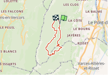

Length
10.8 km

Max alt
1147 m

Uphill gradient
460 m
Km-Effort
16.9 km

Min alt
753 m

Downhill gradient
462 m
Boucle
Yes
Creation date :
2023-03-28 07:41:21.663
Updated on :
2023-03-29 16:06:09.71
3h50
Difficulty : Difficult

FREE GPS app for hiking
 SityTrail
IGN / Geographical institutes
SityTrail Plus
The world is yours!
About
Trail Walking of 10.8 km to be discovered at Auvergne-Rhône-Alpes, Isère, Claix. This trail is proposed by André Rigollier.
Description
super
Positioning
Country:
France
Region :
Auvergne-Rhône-Alpes
Department/Province :
Isère
Municipality :
Claix
Location:
Unknown
Start:(Dec)
Start:(UTM)
708120 ; 4999893 (31T) N.
Comments