Trail Walking Andoain - CANAL DES MILLE MARCHES - CANAL DE VILLABONA Otieta Parkea  - Photo

CANAL DES MILLE MARCHES - CANAL DE VILLABONA Otieta Parkea

 DECHAMPD
DECHAMPD

User

© OpenStreetMap contributors
Length
Length
10.9 km
Max alt
Max alt
320 m
Uphill gradient
Uphill gradient
404 m
Km-Effort
Km-Effort  
16.2 km
Min alt
Min alt
89 m
Downhill gradient
Downhill gradient
400 m
Boucle
Boucle
Yes
Creation date :
2023-03-28 08:45:21.0
Updated on :
2023-04-02 11:03:26.369

(0 Reviews)

Walking
Walking
3h41
Difficulty : Difficult

Scan this QR Code to open this trail in the SityTrail application

FREE GPS app for hiking

Logo SityTrail SityTrail

IGN / Geographical institutes

Download SityTrail from the App Store Download SityTrail from Google Play

Logo SityTrail SityTrail World

The world is yours!

Download SityTrail from the App Store Download SityTrail from Google Play Download SityTrail on Huawei AppGallery

About

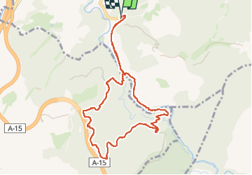
Trail Walking of 10.9 km to be discovered at Autonomous Community of the Basque Country, Gipuzkoa, Andoain. This trail is proposed by DECHAMPD.

Description

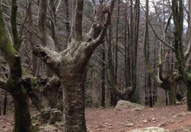
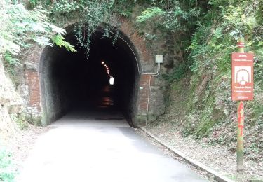
Le PR-GI 118 appelé le Paseo de los canaux; également appelé canal Villabona, canal Leitzarán, canal Iberdrola ou, comme il est mieux connu : le canal aux mille marches.
Un ouvrage d'art de plus de 13 km destiné à capter les eaux des ruisseaux de la rive gauche de la rivière Leizarán pour les amener à la centrale de Bertxin. Une chute d'eau, à travers un tuyau d'un peu plus d'un mètre de diamètre, avec une chute d'environ 100 mètres, et avec un canal d'environ 1000 litres par seconde, descend à travers le pipeline vers l'usine, une turbine de type Francis générant de l'énergie électrique. Aujourd'hui, c'est la centrale électrique la plus puissante du territoire de Gipuzkoa. Depuis la centrale électrique de Bertxin. Les escaliers, avec environ 2x500 marches, ont fait de cet endroit connu comme "Les mille marches". La montée de ces escaliers est accompagnée de bout en bout par une main courante et il est recommandé de s'arrêter toutes les 100 marches. C'est un site bien connu dans la région.

Elevation profile

Photos

29 photos in total. Please click on a photo to see them all in the gallery.

Positioning

Country:
Spain
Region :
Autonomous Community of the Basque Country
Department/Province :
Gipuzkoa
Municipality :
Andoain
Location:
Unknown
Start:(UTM)
580516 ; 4783809 (30T) N.

Trails nearby

Trail On foot Andoain - Andoain / Urnieta - Photo
On foot
PRO

On foot

Easy
Andoain, Autonomous Community of the Basque Country, Gipuzkoa, Spain
5.1 km | 6.2 km-effort
1h 24min
No
Trail On foot Andoain - Andoain / Usurbil - Photo
On foot
PRO

On foot

Medium
Andoain, Autonomous Community of the Basque Country, Gipuzkoa, Spain
16 km | 24 km-effort
5h 22min
No
Trail On foot Urnieta - SL-GI 43 Besadegi - Muniskue - Oindi - Photo
On foot
PRO

On foot

Easy
Urnieta, Autonomous Community of the Basque Country, Gipuzkoa, Spain
6.6 km | 10.3 km-effort
2h 20min
Yes
Trail On foot Andoain - SL-GI 30 Ubaranen bidetik - Photo
On foot
PRO

On foot

Easy
Andoain, Autonomous Community of the Basque Country, Gipuzkoa, Spain
3.1 km | 5.3 km-effort
1h 12min
Yes
Trail On foot Hernani - HIU-3 Oindiri bira - Photo
On foot
PRO

On foot

Easy
Hernani, Autonomous Community of the Basque Country, Gipuzkoa, Spain
8.3 km | 13 km-effort
2h 57min
Yes


Close
My subscriptions