


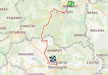
Chomelix centre - Bellevue la montagne

MAD-CVW
User

Length
9.2 km

Max alt
996 m

Uphill gradient
205 m
Km-Effort
11.7 km

Min alt
882 m

Downhill gradient
114 m
Boucle
No
Creation date :
2023-03-28 13:06:31.265
Updated on :
2023-03-28 16:45:08.843
2h55
Difficulty : Medium

FREE GPS app for hiking
 SityTrail
IGN / Geographical institutes
SityTrail Plus
The world is yours!
About
Trail Walking of 9.2 km to be discovered at Auvergne-Rhône-Alpes, Haute-Loire, Chomelix. This trail is proposed by MAD-CVW.
Description
a partir de Chomelix suite déviation du GR765 et Coquille
Positioning
Country:
France
Region :
Auvergne-Rhône-Alpes
Department/Province :
Haute-Loire
Municipality :
Chomelix
Location:
Unknown
Start:(Dec)
Start:(UTM)
565106 ; 5012627 (31T) N.
Comments