


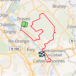
RIS-ORANGIS - CORBEIL-ESSONNES

NUITEVEN
User

Length
26 km

Max alt
96 m

Uphill gradient
243 m
Km-Effort
29 km

Min alt
26 m

Downhill gradient
238 m
Boucle
No
Creation date :
2014-12-10 00:00:00.0
Updated on :
2014-12-10 00:00:00.0
6h24
Difficulty : Easy

FREE GPS app for hiking
 SityTrail
IGN / Geographical institutes
SityTrail Plus
The world is yours!
About
Trail Walking of 26 km to be discovered at Ile-de-France, Essonne, Ris-Orangis. This trail is proposed by NUITEVEN.
Positioning
Country:
France
Region :
Ile-de-France
Department/Province :
Essonne
Municipality :
Ris-Orangis
Location:
Unknown
Start:(Dec)
Start:(UTM)
456910 ; 5389751 (31U) N.
Comments