


chasselas

janussity
User
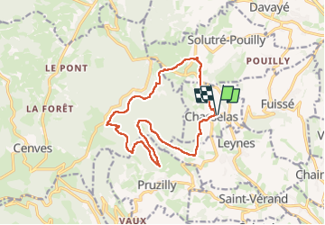

Length
14.4 km

Max alt
652 m

Uphill gradient
481 m
Km-Effort
21 km

Min alt
311 m

Downhill gradient
480 m
Boucle
Yes
Creation date :
2023-03-23 12:48:27.368
Updated on :
2023-03-29 15:25:58.444
3h05
Difficulty : Medium

FREE GPS app for hiking
 SityTrail
IGN / Geographical institutes
SityTrail Plus
The world is yours!
About
Trail Walking of 14.4 km to be discovered at Bourgogne-Franche-Comté, Saône-et-Loire, Chasselas. This trail is proposed by janussity.
Description
couvert. belle rando
Positioning
Country:
France
Region :
Bourgogne-Franche-Comté
Department/Province :
Saône-et-Loire
Municipality :
Chasselas
Location:
Unknown
Start:(Dec)
Start:(UTM)
632616 ; 5126248 (31T) N.
Comments