


Montélimar Grignan 85km

thonyc
User GUIDE
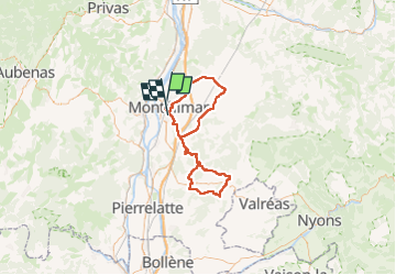

Length
85 km

Max alt
333 m

Uphill gradient
1057 m
Km-Effort
99 km

Min alt
80 m

Downhill gradient
1046 m
Boucle
No
Creation date :
2023-03-29 17:26:44.607
Updated on :
2023-04-04 06:08:32.213
4h20
Difficulty : Medium

FREE GPS app for hiking
 SityTrail
IGN / Geographical institutes
SityTrail Plus
The world is yours!
About
Trail Road bike of 85 km to be discovered at Auvergne-Rhône-Alpes, Drôme, Montélimar. This trail is proposed by thonyc.
Positioning
Country:
France
Region :
Auvergne-Rhône-Alpes
Department/Province :
Drôme
Municipality :
Montélimar
Location:
Unknown
Start:(Dec)
Start:(UTM)
638507 ; 4934968 (31T) N.
Comments