


J8

MAD-CVW
User

Length
28 km

Max alt
991 m

Uphill gradient
492 m
Km-Effort
36 km

Min alt
613 m

Downhill gradient
767 m
Boucle
No
Creation date :
2023-03-29 07:10:58.467
Updated on :
2023-03-30 08:37:58.007
6h16
Difficulty : Very difficult

FREE GPS app for hiking
 SityTrail
IGN / Geographical institutes
SityTrail Plus
The world is yours!
About
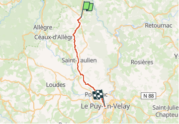
Trail Walking of 28 km to be discovered at Auvergne-Rhône-Alpes, Haute-Loire, Bellevue-la-Montagne. This trail is proposed by MAD-CVW.
Positioning
Country:
France
Region :
Auvergne-Rhône-Alpes
Department/Province :
Haute-Loire
Municipality :
Bellevue-la-Montagne
Location:
Unknown
Start:(Dec)
Start:(UTM)
564301 ; 5007674 (31T) N.
Comments