


J11-réalisé

MAD-CVW
User

Length
20 km

Max alt
1101 m

Uphill gradient
693 m
Km-Effort
29 km

Min alt
592 m

Downhill gradient
613 m
Boucle
No
Creation date :
2023-04-01 06:45:12.608
Updated on :
2023-04-02 13:57:27.316
5h23
Difficulty : Very difficult

FREE GPS app for hiking
 SityTrail
IGN / Geographical institutes
SityTrail Plus
The world is yours!
About
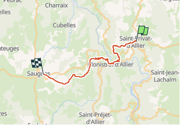
Trail Walking of 20 km to be discovered at Auvergne-Rhône-Alpes, Haute-Loire, Saint-Privat-d'Allier. This trail is proposed by MAD-CVW.
Description
Départ St Privat, très belle rando par sentiers jusqu'au plateau de Sorgues.
Positioning
Country:
France
Region :
Auvergne-Rhône-Alpes
Department/Province :
Haute-Loire
Municipality :
Saint-Privat-d'Allier
Location:
Saint-Privat-d'Allier
Start:(Dec)
Start:(UTM)
553497 ; 4982090 (31T) N.
Comments