


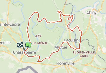
Chassepierre Promenade 22km

xtislair
User

Length
22 km

Max alt
394 m

Uphill gradient
480 m
Km-Effort
29 km

Min alt
275 m

Downhill gradient
477 m
Boucle
Yes
Creation date :
2023-04-02 17:08:42.991
Updated on :
2023-04-03 18:11:32.337
6h33
Difficulty : Very difficult

FREE GPS app for hiking
 SityTrail
IGN / Geographical institutes
SityTrail Plus
The world is yours!
About
Trail Walking of 22 km to be discovered at Wallonia, Luxembourg, Florenville. This trail is proposed by xtislair.
Positioning
Country:
Belgium
Region :
Wallonia
Department/Province :
Luxembourg
Municipality :
Florenville
Location:
Unknown
Start:(Dec)
Start:(UTM)
663074 ; 5508689 (31U) N.
Comments