2023-04-02_19h50m15_serre de vinobre - v3

Linerou
User

Length
6.5 km

Max alt
359 m

Uphill gradient
194 m
Km-Effort
9.1 km

Min alt
180 m

Downhill gradient
194 m
Boucle
Yes
Creation date :
2023-04-02 17:50:15.885
Updated on :
2023-12-31 11:09:59.174
2h04
Difficulty : Easy

FREE GPS app for hiking
 SityTrail
IGN / Geographical institutes
SityTrail Plus
The world is yours!
About
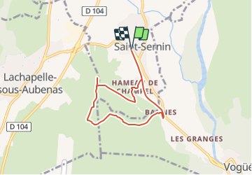
Trail Walking of 6.5 km to be discovered at Auvergne-Rhône-Alpes, Ardèche, Saint-Sernin. This trail is proposed by Linerou.
Positioning
Country:
France
Region :
Auvergne-Rhône-Alpes
Department/Province :
Ardèche
Municipality :
Saint-Sernin
Location:
Unknown
Start:(Dec)
Start:(UTM)
610324 ; 4936157 (31T) N.
Comments