


j12

MAD-CVW
User
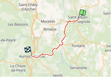

Length
16.4 km

Max alt
1104 m

Uphill gradient
434 m
Km-Effort
22 km

Min alt
918 m

Downhill gradient
349 m
Boucle
No
Creation date :
2023-04-03 07:52:28.24
Updated on :
2023-04-03 13:23:57.618
3h58
Difficulty : Very difficult

FREE GPS app for hiking
 SityTrail
IGN / Geographical institutes
SityTrail Plus
The world is yours!
About
Trail Walking of 16.4 km to be discovered at Occitania, Lozère, Saint-Alban-sur-Limagnole. This trail is proposed by MAD-CVW.
Positioning
Country:
France
Region :
Occitania
Department/Province :
Lozère
Municipality :
Saint-Alban-sur-Limagnole
Location:
Unknown
Start:(Dec)
Start:(UTM)
530668 ; 4958694 (31T) N.
Comments