


20230404-pont St Pierre

doudet
User
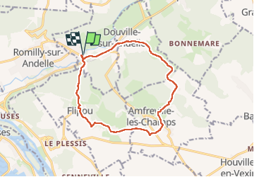

Length
12.8 km

Max alt
156 m

Uphill gradient
275 m
Km-Effort
16.5 km

Min alt
15 m

Downhill gradient
275 m
Boucle
Yes
Creation date :
2023-04-04 11:46:59.193
Updated on :
2023-04-05 07:03:33.47
3h43
Difficulty : Medium

FREE GPS app for hiking
 SityTrail
IGN / Geographical institutes
SityTrail Plus
The world is yours!
About
Trail Walking of 12.8 km to be discovered at Normandy, Eure, Pont-Saint-Pierre. This trail is proposed by doudet.
Photos


Positioning
Country:
France
Region :
Normandy
Department/Province :
Eure
Municipality :
Pont-Saint-Pierre
Location:
Unknown
Start:(Dec)
Start:(UTM)
375067 ; 5465828 (31U) N.
Comments