


Recee Transardennaise

guy284
User

Length
17.7 km

Max alt
424 m

Uphill gradient
527 m
Km-Effort
25 km

Min alt
231 m

Downhill gradient
650 m
Boucle
No
Creation date :
2023-04-04 16:09:53.472
Updated on :
2023-04-04 16:15:30.398
5h43
Difficulty : Very difficult

FREE GPS app for hiking
 SityTrail
IGN / Geographical institutes
SityTrail Plus
The world is yours!
About
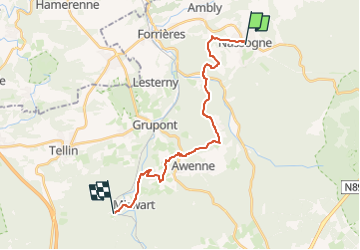
Trail Walking of 17.7 km to be discovered at Wallonia, Luxembourg, Nassogne. This trail is proposed by guy284.
Description
Nassogne - Mirwart (Domaine provincial)
Positioning
Country:
Belgium
Region :
Wallonia
Department/Province :
Luxembourg
Municipality :
Nassogne
Location:
Unknown
Start:(Dec)
Start:(UTM)
667381 ; 5555496 (31U) N.
Comments