


barbas harbouey vezouze

Titinechris
User
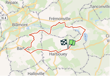

Length
14.5 km

Max alt
315 m

Uphill gradient
168 m
Km-Effort
16.7 km

Min alt
255 m

Downhill gradient
170 m
Boucle
Yes
Creation date :
2023-04-05 13:05:52.249
Updated on :
2023-04-05 13:06:28.536
0m
Difficulty : Very easy

FREE GPS app for hiking
 SityTrail
IGN / Geographical institutes
SityTrail Plus
The world is yours!
About
Trail Running of 14.5 km to be discovered at Grand Est, Meurthe-et-Moselle, Harbouey. This trail is proposed by Titinechris.
Positioning
Country:
France
Region :
Grand Est
Department/Province :
Meurthe-et-Moselle
Municipality :
Harbouey
Location:
Unknown
Start:(Dec)
Start:(UTM)
344932 ; 5382098 (32U) N.
Comments