


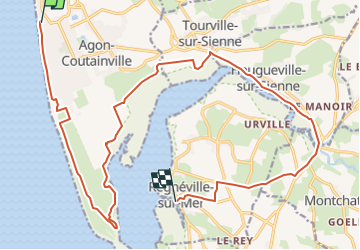
SityTrail - 2023-05-03 Agon-Régnéville A

nolsim
User

Length
22 km

Max alt
41 m

Uphill gradient
124 m
Km-Effort
23 km

Min alt
0 m

Downhill gradient
123 m
Boucle
No
Creation date :
2023-04-05 14:36:51.011
Updated on :
2023-04-05 14:37:13.37

FREE GPS app for hiking
 SityTrail
IGN / Geographical institutes
SityTrail Plus
The world is yours!
About
Trail of 22 km to be discovered at Normandy, Manche, Agon-Coutainville. This trail is proposed by nolsim.
Positioning
Country:
France
Region :
Normandy
Department/Province :
Manche
Municipality :
Agon-Coutainville
Location:
Unknown
Start:(Dec)
Start:(UTM)
602270 ; 5433750 (30U) N.
Comments