


saint Benoît en divois

panetJeanLuc
User
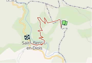

Length
2.9 km

Max alt
595 m

Uphill gradient
41 m
Km-Effort
4.1 km

Min alt
347 m

Downhill gradient
239 m
Boucle
No
Creation date :
2023-04-05 13:53:31.357
Updated on :
2023-04-05 14:47:09.34
41m
Difficulty : Easy

FREE GPS app for hiking
 SityTrail
IGN / Geographical institutes
SityTrail Plus
The world is yours!
About
Trail Walking of 2.9 km to be discovered at Auvergne-Rhône-Alpes, Drôme, Saint-Benoit-en-Diois. This trail is proposed by panetJeanLuc.
Positioning
Country:
France
Region :
Auvergne-Rhône-Alpes
Department/Province :
Drôme
Municipality :
Saint-Benoit-en-Diois
Location:
Unknown
Start:(Dec)
Start:(UTM)
680922 ; 4948486 (31T) N.
Comments