


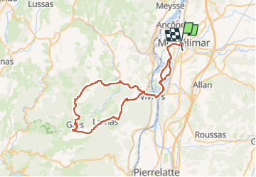
Montélimar-Gras-Bayne 70km

thonyc
User GUIDE

Length
70 km

Max alt
372 m

Uphill gradient
1014 m
Km-Effort
83 km

Min alt
60 m

Downhill gradient
1003 m
Boucle
No
Creation date :
2023-04-05 11:33:17.215
Updated on :
2023-04-07 06:36:20.973
3h53
Difficulty : Medium

FREE GPS app for hiking
 SityTrail
IGN / Geographical institutes
SityTrail Plus
The world is yours!
About
Trail Road bike of 70 km to be discovered at Auvergne-Rhône-Alpes, Drôme, Montélimar. This trail is proposed by thonyc.
Positioning
Country:
France
Region :
Auvergne-Rhône-Alpes
Department/Province :
Drôme
Municipality :
Montélimar
Location:
Unknown
Start:(Dec)
Start:(UTM)
638543 ; 4934946 (31T) N.
Comments