


R2a-verrieres

Jack-94
User
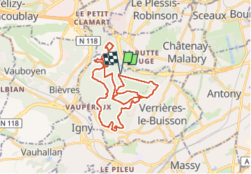

Length
18.4 km

Max alt
182 m

Uphill gradient
300 m
Km-Effort
22 km

Min alt
101 m

Downhill gradient
300 m
Boucle
Yes
Creation date :
2023-04-06 19:21:52.262
Updated on :
2023-04-06 20:13:46.866
5h05
Difficulty : Very difficult

FREE GPS app for hiking
 SityTrail
IGN / Geographical institutes
SityTrail Plus
The world is yours!
About
Trail Walking of 18.4 km to be discovered at Ile-de-France, Essonne, Verrières-le-Buisson. This trail is proposed by Jack-94.
Positioning
Country:
France
Region :
Ile-de-France
Department/Province :
Essonne
Municipality :
Verrières-le-Buisson
Location:
Unknown
Start:(Dec)
Start:(UTM)
444512 ; 5401048 (31U) N.
Comments