


courir

theo89
User

Length
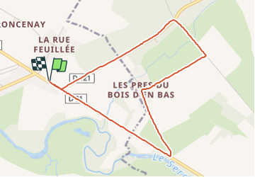
4.4 km

Max alt
121 m

Uphill gradient
30 m
Km-Effort
4.8 km

Min alt
108 m

Downhill gradient
30 m
Boucle
Yes
Creation date :
2014-12-10 00:00:00.0
Updated on :
2014-12-10 00:00:00.0
25m
Difficulty : Unknown

FREE GPS app for hiking
 SityTrail
IGN / Geographical institutes
SityTrail Plus
The world is yours!
About
Trail Running of 4.4 km to be discovered at Bourgogne-Franche-Comté, Yonne, Pontigny. This trail is proposed by theo89.
Positioning
Country:
France
Region :
Bourgogne-Franche-Comté
Department/Province :
Yonne
Municipality :
Pontigny
Location:
Unknown
Start:(Dec)
Start:(UTM)
554165 ; 5307145 (31T) N.
Comments