


St Marc bouclette sympa

thomarche
User
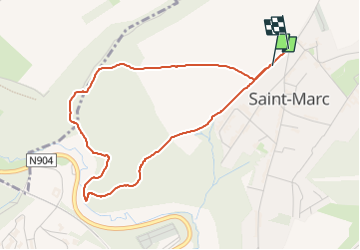

Length
3.9 km

Max alt
186 m

Uphill gradient
101 m
Km-Effort
5.3 km

Min alt
113 m

Downhill gradient
100 m
Boucle
Yes
Creation date :
2023-04-08 15:06:44.0
Updated on :
2023-04-08 15:51:54.111
44m
Difficulty : Easy

FREE GPS app for hiking
 SityTrail
IGN / Geographical institutes
SityTrail Plus
The world is yours!
About
Trail Walking of 3.9 km to be discovered at Wallonia, Namur, Namur. This trail is proposed by thomarche.
Description
Chemins
Positioning
Country:
Belgium
Region :
Wallonia
Department/Province :
Namur
Municipality :
Namur
Location:
Unknown
Start:(Dec)
Start:(UTM)
630960 ; 5595184 (31U) N.
Comments