


ALEX VILLARDS DESSUS DESSOUS

COMAN
User
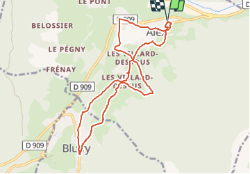

Length
9.4 km

Max alt
829 m

Uphill gradient
362 m
Km-Effort
14.2 km

Min alt
584 m

Downhill gradient
363 m
Boucle
Yes
Creation date :
2014-12-10 00:00:00.0
Updated on :
2014-12-10 00:00:00.0
3h03
Difficulty : Easy

FREE GPS app for hiking
 SityTrail
IGN / Geographical institutes
SityTrail Plus
The world is yours!
About
Trail Walking of 9.4 km to be discovered at Auvergne-Rhône-Alpes, Upper Savoy, Alex. This trail is proposed by COMAN.
Positioning
Country:
France
Region :
Auvergne-Rhône-Alpes
Department/Province :
Upper Savoy
Municipality :
Alex
Location:
Unknown
Start:(Dec)
Start:(UTM)
285894 ; 5085629 (32T) N.
Comments