


les vingt cinq pont / l'escaillon /les campons

Michel DUBOIS
User
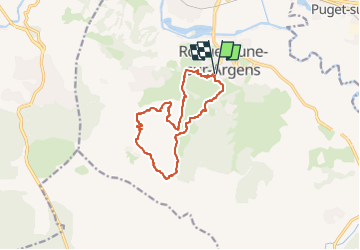

Length
12.5 km

Max alt
259 m

Uphill gradient
424 m
Km-Effort
18.1 km

Min alt
22 m

Downhill gradient
423 m
Boucle
Yes
Creation date :
2023-04-10 10:06:37.467
Updated on :
2023-04-10 10:08:07.97
4h07
Difficulty : Medium

FREE GPS app for hiking
 SityTrail
IGN / Geographical institutes
SityTrail Plus
The world is yours!
About
Trail Walking of 12.5 km to be discovered at Provence-Alpes-Côte d'Azur, Var, Roquebrune-sur-Argens. This trail is proposed by Michel DUBOIS.
Description
a reconnaitre
Positioning
Country:
France
Region :
Provence-Alpes-Côte d'Azur
Department/Province :
Var
Municipality :
Roquebrune-sur-Argens
Location:
Unknown
Start:(Dec)
Start:(UTM)
308514 ; 4812389 (32T) N.
Comments