


La Lucey’n 2023

PhilippeC54
User
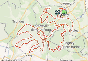

Length
50 km

Max alt
383 m

Uphill gradient
942 m
Km-Effort
62 km

Min alt
253 m

Downhill gradient
937 m
Boucle
Yes
Creation date :
2023-04-10 05:49:24.385
Updated on :
2023-04-10 15:14:55.264
3h57
Difficulty : Difficult

FREE GPS app for hiking
 SityTrail
IGN / Geographical institutes
SityTrail Plus
The world is yours!
About
Trail Mountain bike of 50 km to be discovered at Grand Est, Meurthe-et-Moselle, Lucey. This trail is proposed by PhilippeC54.
Positioning
Country:
France
Region :
Grand Est
Department/Province :
Meurthe-et-Moselle
Municipality :
Lucey
Location:
Unknown
Start:(Dec)
Start:(UTM)
708359 ; 5400139 (31U) N.
Comments