


Vieux Reng

mjh
User
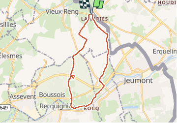

Length
12.5 km

Max alt
158 m

Uphill gradient
95 m
Km-Effort
13.8 km

Min alt
121 m

Downhill gradient
95 m
Boucle
Yes
Creation date :
2023-04-10 08:12:43.874
Updated on :
2023-04-10 12:28:34.344
3h00
Difficulty : Easy

FREE GPS app for hiking
 SityTrail
IGN / Geographical institutes
SityTrail Plus
The world is yours!
About
Trail Walking of 12.5 km to be discovered at Hauts-de-France, Nord, Vieux-Reng. This trail is proposed by mjh.
Photos


Positioning
Country:
France
Region :
Hauts-de-France
Department/Province :
Nord
Municipality :
Vieux-Reng
Location:
Unknown
Start:(Dec)
Start:(UTM)
575954 ; 5575461 (31U) N.
Comments