


2023-04-11_17h55m50_SityTrail - 3604346 - dexlaxverrierexaxtrappes

jpcccb
User
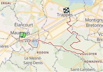

Length
14.4 km

Max alt
178 m

Uphill gradient
139 m
Km-Effort
16.3 km

Min alt
124 m

Downhill gradient
141 m
Boucle
No
Creation date :
2023-04-11 15:55:50.693
Updated on :
2023-05-09 12:34:00.459
3h42
Difficulty : Difficult

FREE GPS app for hiking
 SityTrail
IGN / Geographical institutes
SityTrail Plus
The world is yours!
About
Trail Walking of 14.4 km to be discovered at Ile-de-France, Yvelines, La Verrière. This trail is proposed by jpcccb.
Description
Château de la Verrière, Étang des Noës, Forêt de Port Royal, chemin Jean Racine, Abbaye de Port Royal, Étang du Manet.
Positioning
Country:
France
Region :
Ile-de-France
Department/Province :
Yvelines
Municipality :
La Verrière
Location:
Unknown
Start:(Dec)
Start:(UTM)
422352 ; 5400767 (31U) N.
Comments