


Montélimar Grignan Donzère 72km

thonyc
User GUIDE
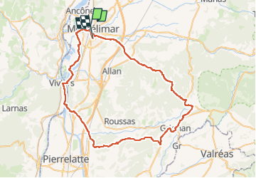

Length
72 km

Max alt
434 m

Uphill gradient
907 m
Km-Effort
84 km

Min alt
54 m

Downhill gradient
894 m
Boucle
No
Creation date :
2023-04-12 11:32:36.016
Updated on :
2023-04-22 12:07:10.717
5h00
Difficulty : Medium

FREE GPS app for hiking
 SityTrail
IGN / Geographical institutes
SityTrail Plus
The world is yours!
About
Trail Road bike of 72 km to be discovered at Auvergne-Rhône-Alpes, Drôme, Montélimar. This trail is proposed by thonyc.
Positioning
Country:
France
Region :
Auvergne-Rhône-Alpes
Department/Province :
Drôme
Municipality :
Montélimar
Location:
Unknown
Start:(Dec)
Start:(UTM)
638544 ; 4934933 (31T) N.
Comments