


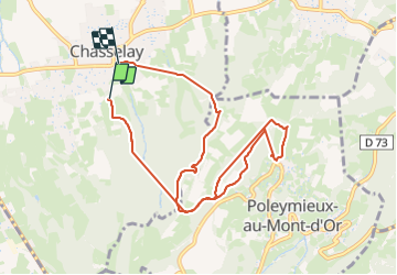
Chasselay Sentier géologique

Jean-Marc C
User

Length
9.5 km

Max alt
560 m

Uphill gradient
425 m
Km-Effort
15.3 km

Min alt
242 m

Downhill gradient
459 m
Boucle
No
Creation date :
2023-04-06 07:04:26.683
Updated on :
2023-08-30 09:01:27.478
2h20
Difficulty : Difficult

FREE GPS app for hiking
 SityTrail
IGN / Geographical institutes
SityTrail Plus
The world is yours!
About
Trail Walking of 9.5 km to be discovered at Auvergne-Rhône-Alpes, Rhône, Chasselay. This trail is proposed by Jean-Marc C.
Positioning
Country:
France
Region :
Auvergne-Rhône-Alpes
Department/Province :
Rhône
Municipality :
Chasselay
Location:
Unknown
Start:(Dec)
Start:(UTM)
637498 ; 5081042 (31T) N.
Comments