


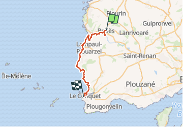
7-Brélès-Le Conquet 30km

thonyc
User GUIDE

Length
30 km

Max alt
52 m

Uphill gradient
373 m
Km-Effort
35 km

Min alt
0 m

Downhill gradient
392 m
Boucle
No
Creation date :
2023-04-14 08:44:33.776
Updated on :
2023-04-14 08:56:12.342
8h00
Difficulty : Difficult

FREE GPS app for hiking
 SityTrail
IGN / Geographical institutes
SityTrail Plus
The world is yours!
About
Trail Walking of 30 km to be discovered at Brittany, Finistère, Brélès. This trail is proposed by thonyc.
Positioning
Country:
France
Region :
Brittany
Department/Province :
Finistère
Municipality :
Brélès
Location:
Unknown
Start:(Dec)
Start:(UTM)
373357 ; 5370866 (30U) N.
Comments