Trail Walking Fontaine-Chaalis - t264479859_bois de perthe - Photo

t264479859_bois de perthe

© OpenStreetMap contributors
Length
Length
6.3 km
Max alt
Max alt
133 m
Uphill gradient
Uphill gradient
92 m
Km-Effort
Km-Effort  
7.5 km
Min alt
Min alt
70 m
Downhill gradient
Downhill gradient
90 m
Boucle
Boucle
Yes
Creation date :
2023-04-14 09:09:51.596
Updated on :
2023-04-16 17:12:09.82

(0 Reviews)

Walking
Walking
1h42
Difficulty : Medium

Scan this QR Code to open this trail in the SityTrail application

FREE GPS app for hiking

Logo SityTrail SityTrail

IGN / Geographical institutes

Download SityTrail from the App Store Download SityTrail from Google Play

Logo SityTrail SityTrail Plus

The world is yours!

Download SityTrail from the App Store Download SityTrail from Google Play Download SityTrail on Huawei AppGallery

About

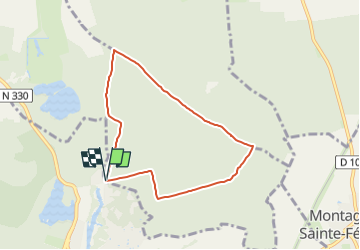
Trail Walking of 6.3 km to be discovered at Hauts-de-France, Oise, Fontaine-Chaalis. This trail is proposed by Pousscailleux.

Description

Arbre remarquable, "l'Ancêtre de Perthe", N 49° 08.254 / E 002° 43.494, 37 m de haut et âgé de 250 ans, peut-être le plus vieux chêne sessile de cette forêt, n'est plus. Déjà déclaré "arbre solide mais à surveiller" en mai 2002 par un expert de l'ONF, et dépourvu de feuillage en 2016, il est, comme beaucoup d'autres grands arbres de sa section, définitivement manquant.

Elevation profile

Positioning

Country:
France
Region :
Hauts-de-France
Department/Province :
Oise
Municipality :
Fontaine-Chaalis
Location:
Unknown
Start:(UTM)
477878 ; 5442544 (31U) N.


Close
My subscriptions