


R1T-A517-Halatte

Jack-94
User
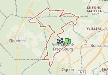

Length
21 km

Max alt
239 m

Uphill gradient
369 m
Km-Effort
25 km

Min alt
92 m

Downhill gradient
367 m
Boucle
Yes
Creation date :
2023-04-08 07:55:34.672
Updated on :
2023-07-07 12:46:33.235
6h14
Difficulty : Very difficult

FREE GPS app for hiking
 SityTrail
IGN / Geographical institutes
SityTrail Plus
The world is yours!
About
Trail Walking of 21 km to be discovered at Hauts-de-France, Oise, Villers-Saint-Frambourg-Ognon. This trail is proposed by Jack-94.
Positioning
Country:
France
Region :
Hauts-de-France
Department/Province :
Oise
Municipality :
Villers-Saint-Frambourg-Ognon
Location:
Unknown
Start:(Dec)
Start:(UTM)
473758 ; 5455828 (31U) N.
Comments