


Chemin de Fontête

Gegetop
User

Length
8.6 km

Max alt
592 m

Uphill gradient
240 m
Km-Effort
11.9 km

Min alt
363 m

Downhill gradient
258 m
Boucle
Yes
Creation date :
2014-12-10 00:00:00.0
Updated on :
2014-12-10 00:00:00.0
2h06
Difficulty : Easy

FREE GPS app for hiking
 SityTrail
IGN / Geographical institutes
SityTrail Plus
The world is yours!
About
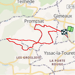
Trail Walking of 8.6 km to be discovered at Auvergne-Rhône-Alpes, Puy-de-Dôme, Gimeaux. This trail is proposed by Gegetop.
Description
Jolie balade qui vous emmène au milieu des cultures en passant par Prompsat et Fonfrède à travers un paysage vallonné et toujours d'accés facile.
Photos


Positioning
Country:
France
Region :
Auvergne-Rhône-Alpes
Department/Province :
Puy-de-Dôme
Municipality :
Gimeaux
Location:
Unknown
Start:(Dec)
Start:(UTM)
507467 ; 5087683 (31T) N.
Comments
Très agréable à faire en famille.