


T-A516-Chamarande

Jack-94
User
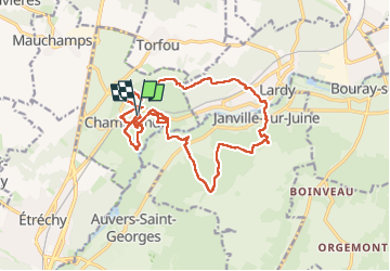

Length
18.1 km

Max alt
164 m

Uphill gradient
328 m
Km-Effort
22 km

Min alt
58 m

Downhill gradient
329 m
Boucle
Yes
Creation date :
2023-04-15 07:21:43.527
Updated on :
2023-04-16 07:57:58.632
6h36
Difficulty : Very difficult

FREE GPS app for hiking
 SityTrail
IGN / Geographical institutes
SityTrail Plus
The world is yours!
About
Trail Walking of 18.1 km to be discovered at Ile-de-France, Essonne, Chamarande. This trail is proposed by Jack-94.
Positioning
Country:
France
Region :
Ile-de-France
Department/Province :
Essonne
Municipality :
Chamarande
Location:
Unknown
Start:(Dec)
Start:(UTM)
442493 ; 5373853 (31U) N.
Comments