


St auban sur Ouvèze la Vanige

Monjean
User

Length
16.2 km

Max alt
1372 m

Uphill gradient
977 m
Km-Effort
29 km

Min alt
702 m

Downhill gradient
977 m
Boucle
Yes
Creation date :
2023-04-16 07:14:33.584
Updated on :
2023-04-18 11:18:17.455
7h15
Difficulty : Very difficult

FREE GPS app for hiking
 SityTrail
IGN / Geographical institutes
SityTrail Plus
The world is yours!
About
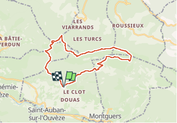
Trail Walking of 16.2 km to be discovered at Auvergne-Rhône-Alpes, Drôme, Saint-Auban-sur-l'Ouvèze. This trail is proposed by Monjean.
Positioning
Country:
France
Region :
Auvergne-Rhône-Alpes
Department/Province :
Drôme
Municipality :
Saint-Auban-sur-l'Ouvèze
Location:
Unknown
Start:(Dec)
Start:(UTM)
693755 ; 4908245 (31T) N.
Comments