


Olne17

chantalandre
User
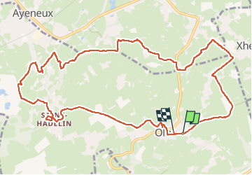

Length
12.8 km

Max alt
276 m

Uphill gradient
233 m
Km-Effort
15.9 km

Min alt
166 m

Downhill gradient
238 m
Boucle
Yes
Creation date :
2023-04-17 07:26:53.0
Updated on :
2023-04-17 10:47:01.191
3h05
Difficulty : Difficult

FREE GPS app for hiking
 SityTrail
IGN / Geographical institutes
SityTrail Plus
The world is yours!
About
Trail Walking of 12.8 km to be discovered at Wallonia, Liège, Olne. This trail is proposed by chantalandre.
Positioning
Country:
Belgium
Region :
Wallonia
Department/Province :
Liège
Municipality :
Olne
Location:
Unknown
Start:(Dec)
Start:(UTM)
694807 ; 5607851 (31U) N.
Comments