


labeville vallongoujard wmezieres

avdem
User
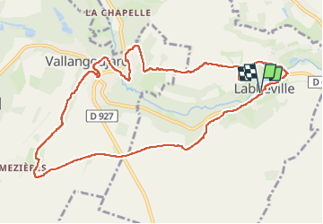

Length
11.1 km

Max alt
111 m

Uphill gradient
152 m
Km-Effort
13.1 km

Min alt
41 m

Downhill gradient
152 m
Boucle
Yes
Creation date :
2023-04-18 07:18:37.813
Updated on :
2023-04-18 10:28:50.628
3h08
Difficulty : Easy

FREE GPS app for hiking
 SityTrail
IGN / Geographical institutes
SityTrail Plus
The world is yours!
About
Trail Walking of 11.1 km to be discovered at Ile-de-France, Val-d'Oise, Labbeville. This trail is proposed by avdem.
Description
tres bien
Photos


Positioning
Country:
France
Region :
Ile-de-France
Department/Province :
Val-d'Oise
Municipality :
Labbeville
Location:
Unknown
Start:(Dec)
Start:(UTM)
437580 ; 5442928 (31U) N.
Comments