


Fred BC Beynat

arnoultjf
User
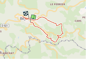

Length
7.1 km

Max alt
509 m

Uphill gradient
189 m
Km-Effort
9.5 km

Min alt
381 m

Downhill gradient
173 m
Boucle
No
Creation date :
2023-04-18 11:38:47.136
Updated on :
2023-04-18 13:57:22.296
2h18
Difficulty : Medium

FREE GPS app for hiking
 SityTrail
IGN / Geographical institutes
SityTrail Plus
The world is yours!
About
Trail Walking of 7.1 km to be discovered at New Aquitaine, Corrèze, Beynat. This trail is proposed by arnoultjf.
Positioning
Country:
France
Region :
New Aquitaine
Department/Province :
Corrèze
Municipality :
Beynat
Location:
Unknown
Start:(Dec)
Start:(UTM)
399753 ; 4997371 (31T) N.
Comments